Thursday, December 25, 2008

christmas tragedy


By Guy McCarthy

WATERMAN CANYON - Five years ago, Christmas also fell on a Thursday.

In 2003 the rains came harder.

They pounded down on slopes that had burned two months before in the Old Fire.

The deluge unleashed tons of ash, trees and boulders in Waterman Canyon and neighboring watersheds.

As darkness fell that evening, no one knew exactly how many people were missing.

Frantic rescue efforts were underway. But no one had dealt with chaos like this before.

Some survivors crawled out of Waterman Canyon on their own. Others in Cable Canyon walked through a river of flowing mud and rock to escape.

Some people - including nine children - did not make it out alive.

One man was found pinned under a log, grieving for a daughter ripped from his arms by the raging flood. San Bernardino City Fire Capt. Vinson Gates tried to console him, but the man was beside himself.

It was pitch black that night, Dec. 25 2003, when Mark and Aileen Andrews sat shivering in the back of an ambulance and described the avalanche of debris that roared down Waterman. Still the rains came, pounding in the darkness, forcing rescuers to abandon their efforts until the next morning.

The Andrewses had watched in horror as a grinding, clashing mix of water, mud and boulders tore out bridges on both sides of them on Old Waterman Canyon Road.

They'd found themselves cut off that afternoon, but low-lying fog and dark clouds made it seem like dusk in the deep canyon above north San Bernardino.

A thundering torrent was still churning 15 feet above the creek bed, four to five feet wide on the roadway in places. In the eerie aftermath of one of the slides, Aileen Andrews said she could hear voices.

"There were people standing in their yards, worried their houses were going to come down," she said. "One of the houses by the river had four big trees that went completely through . . . Some people chose to stay, but we didn't want to. We left about 15 people down there."


Rescues were underway elsewhere, but the Andrewses and others caught between two washed-out bridges were trapped.

Mark Andrews, 45, and Aileen Andrews, 40, of Crestline decided to save themselves. They gathered their courage and climbed the steep, slick, flood-washed slopes for nearly an hour before they came to Highway 18.

"I was climbing literally on my knees," Aileen Andrews said. "We were slipping and sliding. We were about to turn back when the fog lifted and we could see the 18. We made a beeline to the highway and a fire truck picked us up.

"We're grateful to be alive, definitely," she said. "I wasn't on my own though. I give it all to God."

The Andrewses were still in soaked, muddy clothing that evening as they spoke to a group of fire commanders and search-and-rescue volunteers near the top of Waterman Canyon.

"There were people still in there," Mark Andrews told the officials, who pored over a map of the canyon as the pair spoke. "They were by the houses, between those two bridges."

Minutes later, they huddled in the back of the ambulance, parked outside a hastily set-up command center.

Paramedic Lisa Comnick wrapped them in thermal blankets, cranked the ambulance heat on high, and fed them candy canes and salted peanuts still in the shell.

Other ambulances nearby were stuck in mud and debris from continuing slides. Comnick said the Red Cross was going to bring dry clothes and more blankets.

It was unclear at that point whether the Andrewses would be evacuated.

"Our son, Joshua, hasn't even opened his Christmas presents yet," Mark Andrews said. The 11-year-old was staying with a neighbor in Crestline.

The Andrewses said they got trapped on Old Waterman Canyon Road after they tried to avoid slide debris on Highway 18.

"My wife works at San Bernardino Community Hospital and I came down the 18 to pick her up," Mark Andrews said. "The highway was a mess, so we came back up the side road."

"That was a big mistake," Aileen Andrews said. "We saw rocks and water on the road, then it was like a freight train. It was rocks, boulders, trees, whole trees getting knocked down. We couldn't get through."

"We tried to turn around, but the bridge was washing out," she said. "We got out of the car to get to higher ground."

They left their four-wheel-drive Toyota Rav 4 on the shoulder and tried to get their bearings.

"The one bridge was there one minute and we looked back and it was gone," Mark Andrews said. "Then the other was gone."

About 100 yards ahead, an empty car stood on the road, its lights on, engine still running. No one came back for it in the minutes that passed before the Andrewses started trying to climb up to the highway.

"If anyone was standing outside that car when the flood came through
. . . " Mark Andrews said. "They were swept away, gone. Nobody came back to that car."

Two hundred yards behind, another car stood battered and dented in the road, its windows smashed and the hood and trunk lids open. The Andrewses spoke briefly with residents standing in their yards before they left, including a man who lived in one of the flood-damaged homes.

"He was on a cell phone and said, 'I can't come for Christmas because I got a bunch of trees in my living room. And they aren't Christmas trees,' " Mark Andrews said.

The Andrewses' home in Crestline was less than a mile from homes that burned in the Old Fire. They said their escape from fire-induced avalanche and flood was more good fortune.

"I was scared, but I was confident we'd get out too," Aileen Andrews said. "We felt trapped. We had to do something."


-30-

Sixteen people lost their lives that day. It took rescuers many days to uncover and retrieve all the bodies. The last victim from Waterman Canyon was found four months later, 15 miles downstream. Another survivors' story from Christmas 2003 is here.

Note: This account is based on an article originally reported and written for Dec. 26 2003 editions of The Sun newspaper in San Bernardino.

All photos Dec. 26 2003 by Guy McCarthy.

Monday, December 15, 2008

hotshots


By Guy McCarthy

DEL ROSA - Beneath a blanket of drifting fog and low-lying cloud at the base of the San Bernardino Mountains, three firefighters took advantage of stormy weather today to burn a pile of brush at their base in north Del Rosa.

"Nobody's noticed so far," said Jack Masters, a member of the U.S. Forest Service Del Rosa Hotshots. "It's a good day to do this."


To fuel the fire in damp and drizzly conditions, USFS Firefighter Eddie Apodaca had a gas-powered leaf blower strapped to his back and used throttle-controlled wind to stoke embers in the pile to flames.

The high-powered bellows worked as well as a blow-torch.

Masters and Augustin Flores, another member of the local Hotshots, used shovels to help keep the pile burning.


Flores, 22, grew up in Lincoln Heights, East Los Angeles. Masters, 28, grew up in Redlands, San Bernardino and Fontana. Apodaca, 31, grew up in Tustin.

Each of them has seen enough wildfire in recent years. Today was a decent day for a controlled burn.

-30-

Photos by Guy McCarthy

Wednesday, November 26, 2008

stay tuned


By Guy McCarthy

Even if no more heavy rain falls on burned areas, no more wind blows, and nothing else burns for the next year, nature reminded a region who's in charge over the past two and a half weeks.

While many residents in Yorba Linda remain under voluntary evacuation status this evening in the event heavy rains return overnight, a quick recap may be in order before Thanksgiving arrives.

Just two weeks ago, the weather was switching rapidly - from a powerful cold front that contributed to at least eight deaths in San Bernardino County to severe fire weather that helped destroy or damage close to one thousand homes from Santa Barbara to Los Angeles and the Santa Ana River.

Now we have rain when we need it, but it still seems like a curse for those who live in and below the watersheds scorched by fires so far this season.

Whether Yorba Linda and Orange County officials over-compensated for the post-fire erosion threat in the past few days - after firestorms exposed shortcomings in land use planning, emergency response and communications - is irrelevant.

The fact remains that obvious, foreseeable elements like wind, fire and rain again showed how dominant nature can be, and how limited even the nation's best-coordinated local, state and federal agencies are when the real deal goes down.

No matter how many volunteers, firefighters, police officers, pilots and utility workers we organize against fires and floods - there is nothing anyone can do if the winds blow hard enough or if the rains keep coming - except get out of the way.

In the meantime, perhaps everyone needs a break. The weather forecasters, who have been fairly reliable over the past two and half weeks, say we're going to get one.

But keep at least one eye wary.

-30-

mandatory evacuations


Mill Creek Canyon on Tuesday.

Fears of post-fire erosion resulted in mandatory evacuation orders just before 2 a.m. today in vulnerable Yorba Linda neighborhoods, as heavy rains continued pounding the Freeway Complex Fire burned areas.

From the city's web site:

MANDATORY EVACUATIONS ORDERED

"Mandatory evacuations are in effect for the Brush Canyon Area, the Box Canyon Area, and the North Fairmont/San Antonio area. During the mandatory evacuation, the Thomas Lasorda, Jr. Field House (4701 Casa Loma Avenue) will be available as a shelter location."

The Weather Service updated flash flood warnings at 12:40 a.m. and 12:52 a.m. today for the Freeway Complex Fire burned area, in effect until at least 3:45 a.m.

BULLETIN - EAS ACTIVATION REQUESTED
FLASH FLOOD WARNING
NATIONAL WEATHER SERVICE SAN DIEGO CA
1240 AM PST WED NOV 26 2008

* FLASH FLOOD WARNING FOR... EXTREME SOUTHWESTERN SAN BERNARDINO COUNTY IN SOUTHEAST CALIFORNIA... NORTH CENTRAL ORANGE COUNTY IN SOUTHWEST CALIFORNIA... THIS INCLUDES THE CITY OF YORBA LINDA... EXTREME NORTHWESTERN RIVERSIDE COUNTY IN SOUTHWEST CALIFORNIA...

* UNTIL 330 AM PST

* AT 1230 AM PST...RADAR SHOWED NUMEROUS SHOWERS AND ISOLATED THUNDERSTORMS WITH MODERATE TO HEAVY RAINFALL MOVING ACROSS THE BURN AREAS. THIS IS EXPECTED TO CONTINUE THROUGH 2 AM.

INCLUDED IN THE FLASH FLOOD WARNING ARE AREAS THAT BURNED IN THE FREEWAY COMPLEX FIRE. AREAS THAT ARE PRONE TO DEBRIS FLOW INCLUDE OLINDA VILLAGE NEAR BREA...CARBON CANYON...BRUSH CANYON...BOX CANYON AND SAN ANTONIO NEAR YORBA LINDA AND NEAR THE CASCADE APARTMENTS IN ANAHEIM.

DEBRIS FLOWS...INCLUDING MUD AND ROCK SLIDES...ARE EXPECTED WITH THIS STORM. MUD SLIDES AND ROCK SLIDES CAN POTENTIALLY TRAP AND KILL PEOPLE CAUGHT IN THEIR PATH.

RESIDENTS AND MOTORISTS IN AND BELOW RECENTLY BURNED AREAS SHOULD BE ALERT TO HEAVY MUD AND DEBRIS FLOWS WHICH MAY BLOCK ROADS AND CULVERTS. POTENTIALLY DANGEROUS FLOODING AND PROPERTY LOSS COULD RESULT IN AREAS WHERE RUNOFF IS RESTRICTED OR BLOCKED. ADDITIONAL RAINFALL AMOUNTS OF ONE QUARTER TO ONE HALF INCH PER HOUR ARE POSSIBLE IN THE WARNED AREA.

-30-

Tuesday, November 25, 2008

flood warning


Storm over east San Gabriel range Tuesday evening.

Updated warning at 11:57 p.m. for the burned areas in Los Angeles County:

FLASH FLOOD STATEMENT
NATIONAL WEATHER SERVICE OXNARD CA
1157 PM PST TUE NOV 25 2008

...A FLASH FLOOD WARNING REMAINS IN EFFECT UNTIL 1245 AM PST FOR THE SAYRE...MAREK AND SESNON BURN AREAS IN LOS ANGELES COUNTY...

AT 1150 PM PST...NATIONAL WEATHER SERVICE DOPPLER RADAR INDICATED HEAVY RAIN FALLING OVER SAYRE...MAREK AND SESNON BURN AREAS. BRIEFLY INTENSE RAINFALL RATES OF OVER QUARTER OF AN INCH IN 15 MINUTES HAVE BEEN REPORTED IN GAUGES NEAR THE BURN AREA. HEAVY RAIN IS EXPECTED TO PERSIST THROUGH AT LEAST 1245 AM PST WEDNESDAY.

RAINFALL IS EXPECTED TO CAUSE FLASH FLOODS AND DEBRIS FLOWS IN AND AROUND THE SAYRE...MAREK AND SESNON BURN AREAS.

BE ESPECIALLY CAUTIOUS AT NIGHT WHEN IT IS DIFFICULT TO RECOGNIZE THE DANGERS OF FLASH FLOODING AND DEBRIS FLOWS. IF FLASH FLOODING OR DEBRIS FLOWS ARE OBSERVED...ACT QUICKLY.

LAT...LON 3437 11866 3441 11838 3429 11834 3422 11860
3432 11849


$$

As storm cells make their way inland tonight, a flash flood warning has been issued for the burned areas in Los Angeles County.

From the National Weather Service:

BULLETIN - EAS ACTIVATION REQUESTED
FLASH FLOOD WARNING
NATIONAL WEATHER SERVICE OXNARD CA
1118 PM PST TUE NOV 25 2008

THE NATIONAL WEATHER SERVICE IN OXNARD HAS ISSUED A

* FLASH FLOOD WARNING FOR...
THE SAYRE...MAREK AND SESNON BURN AREAS IN
LOS ANGELES COUNTY IN SOUTHWEST CALIFORNIA...

* UNTIL 1245 AM PST

* AT 1105 PM PST...NATIONAL WEATHER SERVICE DOPPLER RADAR INDICATED VERY HEAVY RAIN APPROACHING THE BURN AREAS FROM THE SOUTH. RAINFALL RATES OVER ONE HALF INCH PER HOUR ARE EXPECTED THROUGH 1245 AM PST WEDNESDAY.

* LOCATIONS IN THE WARNING AREA INCLUDE LOCATIONS IN AND NEAR THE SAYRE...MAREK AND SESNON BURN AREAS.

RESIDENTS AND MOTORISTS IN AND BELOW RECENTLY BURNED AREAS SHOULD BE ALERT TO FLASH FLOODING AND DEBRIS FLOWS WHICH MAY BLOCK ROADS AND CULVERTS.

Monday, November 24, 2008

flood watch


Cloud cover over east San Gabriels today.

By Guy McCarthy

A flash flood watch issued at 1 p.m. today for the coming storm has been expanded to include the recent burn areas in Santa Barbara County and the San Fernando Valley.

At 2:27 p.m., a statement from the National Weather Service in Oxnard emphasized the concern for areas scorched by fires:

ALTHOUGH A STORM OF THIS MAGNITUDE THIS TIME OF YEAR WOULD NOT BY ITSELF POSE A RISK FOR LIFE-THREATENING FLOODING...AREAS THAT HAVE BEEN DENUDED FROM RECENT BURNS ARE AT AN INCREASED RISK FOR FLASH FLOODS AND DEBRIS FLOWS...AND THE FLASH FLOOD WATCH IS FOR THESE AREAS ONLY.

The watch area highlighted by the National Weather Service includes the estimated 47 square miles that burned in the Freeway Complex Fire.

If hard rains come to inland areas, they are expected between Tuesday evening and Wednesday evening.

Residents in and below recently burned areas in Orange County have been warned of the potential danger for several days. Sandbagging and other mitigation efforts continue today in Yorba Linda.

Here's the 1 p.m. alert:

* FLASH FLOOD WATCH FOR A PORTION OF SOUTHWEST CALIFORNIA...INCLUDING THE FOLLOWING AREAS...COACHELLA VALLEY...ORANGE COUNTY COASTAL AREAS...RIVERSIDE COUNTY MOUNTAINS...SAN BERNARDINO COUNTY MOUNTAINS...SAN BERNARDINO AND RIVERSIDE COUNTY VALLEYS-THE INLAND EMPIRE...SAN DIEGO COUNTY COASTAL AREAS...SAN DIEGO COUNTY DESERTS...SAN DIEGO COUNTY MOUNTAINS...SAN DIEGO COUNTY VALLEYS AND SANTA ANA MOUNTAINS AND FOOTHILLS.

* FROM TUESDAY EVENING THROUGH WEDNESDAY EVENING

* A STORM APPROACHING FROM THE WEST WILL BRING PERIODS OF MODERATE TO HEAVY RAIN TUESDAY EVENING INTO WEDNESDAY EVENING. THE SNOW LEVEL WILL START OUT QUITE HIGH AND THEN LOWER TO ABOUT 6500 FEET BY WEDNESDAY NIGHT...SO MOST OF THE PRECIPITATION WILL FALL AS RAIN. THIS WILL MAKE FLASH FLOODING POSSIBLE...ESPECIALLY IN AND BELOW RECENTLY BURNED AREAS AND NEAR STEEP TERRAIN.

A FLASH FLOOD WATCH MEANS THAT CONDITIONS MAY DEVELOP THAT LEAD TO FLASH FLOODING. FLASH FLOODING IS A VERY DANGEROUS SITUATION.

-30-

Friday, November 21, 2008

erosion concerns


Yorba Linda subdivision below Chino Hills State Park.

By Guy McCarthy

Yorba Linda city officials warned residents today of potential for devastating post-fire erosion if hard rains hit slopes scorched and denuded by the recent fires.

"Due to the Freeway Complex Fire on November 15-16, nearly all the vegetation on the hillsides along the northern interface between the City and Chino Hills State Park has burned away," Yorba Linda officials said in a statement titled "Post-Fire Rain Events."

"As a result, much of the remaining soil and debris could wash down into surrounding neighborhoods when it rains. These mudflows may result in additional property damage."

More information for Yorba Linda residents is posted here. City of Brea officials have also posted information on erosion control on their site.

Showers are possible in the region next week, according to The Weather Channel.

One reason local governments take the post-fire threat so seriously is the Christmas 2003 deaths of 16 people in canyons north of San Bernardino. Heavy rains on steep mountain slopes burned two months before by the Old Fire unleashed tons of ash, burned soil, boulders and logs. The dead included nine children.

The Los Angeles Times and the Orange County Register have stories here and here.

-30-

Thursday, November 20, 2008

post-fire


Cal Fire investigator Monday in Riverside County.

By Guy McCarthy

A week ago today, nothing had burned.

Not in the past month anyway.

Now scientists are studying massive tracts of blackened earth from Santa Barbara and Sylmar to the Santa Ana River, to quantify how the region's most recent firestorms will impact water quality and slope stability.

Lead agencies include the Orange County Flood Control District and the Orange County Water District.

"The sheriff, the fire authority and the flood control district are working together to understand the impacts of the fire," Nadeem Majaj, assistant chief engineer for Orange County flood control said today in a phone interview.

"We're meeting next week to strategize our preparations for the winter," Majaj said. "We've already inspected dams, basins and channels, in particular the Carbon Canyon Dam. We'll be providing guidance to cities as to what they can expect."

The Freeway Complex Fire burned more than 47 square miles and destroyed or damaged 313 homes, according to Orange County Fire Authority estimates updated today.


Destroyed home Monday in Yorba Linda.

The Freeway Complex Fire started Saturday in Corona and burned into three other counties.

But Orange County will bear the brunt of impacts from the fire, said Jeff Beehler, environmental project manager for the Santa Ana Watershed Project Authority (SAWPA).

In November 2003, the Riverside-based authority prepared a detailed report on how the Old, Grand Prix and Padua fires of October that year could impact the Santa Ana watershed, which is home to more than 5 million people.

The watershed also supplies most of the drinking water for people who live there, according to SAWPA.

A year ago, the authority issued a map showing six fires that impacted the Santa Ana watershed in October 2007, including the Santiago Fire in Orange County and the Slide and Grass Valley fires in the San Bernardino National Forest.

An updated report on fire impacts from SAWPA this year is unlikely, Beehler said Wednesday.

"This is going to impact Orange County," Beehler said.

Last year after the October 2007 fires, the U.S. Geological Survey prepared a report on how ash and burned soil could adversely affect water quality, human health, endangered species, and contribute to debris flow or flooding hazards.

To mitigate potential effects from the burned areas on drinking water supply, the Orange County Water District is diverting as little water as possible from the Santa Ana River into its deep recharge basins, according to Eleanor Torres, a spokeswoman for the district.

The district has more than 1,600 monitoring stations to ensure water quality, Torres said in a phone interview.

"What we're hoping is the first heavy rains will flush the river out," Torres said.

Local, state and federal agencies typically cooperate to form Burned Area Emergency Response teams after any major fire in Southern California. The most recent episode of catastrophic firestorms is no exception.


Destroyed home Monday in Yorba Linda.

Photos by Guy McCarthy

-30-

Monday, November 17, 2008

survivors


Porcelain figures rescued from ashes Monday.

By Guy McCarthy

From Corona to Yorba Linda and Carbon Canyon, it was clear Monday why some forestry and fire specialists have started using the term "fireshed."

It was also obvious that post-fire erosion will be a concern the next time it rains hard on an estimated 45 square miles of blackened slopes and gullies, from the Santa Ana River to the Chino Hills.

But Monday was also a time for survivors of the weekend fires to reflect and count their blessings, while firefighters and utility crews worked into the night for a third day in a row.

Investigators were busy too. Near the point of origin for the so-called Freeway Complex in Corona, a team from Cal Fire worked in a charred field, using red and yellow flags to mark the fire's movement in its earliest stages.

"We're still in the process of conducting the investigation to determine the cause of the fire," said Cal Fire Capt. Marc DeRosier, who is based in San Bernardino. "That has not been determined yet."

DeRosier added that he and his team were assisting the Corona Fire Department with the investigation.

"The red flags designate forward advance of the fire," DeRosier said. "The yellow flags designate lateral progression of the fire."

A few hundred yards away in the first community where homes were damaged, Sandy Brown, 60, felt fortunate most of her house on Feather River Road was still standing.

"I'm not totally surprised by the fire, because the house backs up to wilderness," Brown said. "That's why we bought it, for the view.

"The firefighters were wonderful, of course," Brown said. "Channel 4 showed 10 of them on the roof, chopping away at the flames. The whole roof is a total loss, but the rest of the house is okay."

Brown's tenant, Kay Rains, said she was completely surprised by the fire.

"There was no warning whatsoever," Rains said. "No sirens, no fire engines at first. A lot of smoke, and then the neighbor's yard was on fire.

"People should just be prepared at any time," Rains said. "This can happen to you."

Several miles west and high above the riverbed on Alpine Lane in Yorba Linda, Ron Gibson, 53, made a similar point.

"When they say you have 30 seconds to get out, they mean 30 seconds," Gibson said. "A fireball came over that ridge, six stories high. We had to run for our lives."

Gibson said he and his family barely escaped, and everything else burned, including their vehicles.

"It was like a mushroom cloud that engulfed everything," Gibson said of the flames. "The house is gone. A huge mistake that we built. But the insurance company has told me they'll take care of everything."

Gibson's 19-year-old daughter, Summer, said the loss of her home and belongings rattled her. But she said she also sees a chance to turn over a new leaf.

"My parents told me to pack, but I wasn't listening," she said. "I'm just a spoiled girl with two closets of clothes, who always had everything. Now all that's gone.

"This is really a reality check. I feel sorry for my neighbors. But I still feel fortunate."

On San Antonio Road, 18-year-old Richard Fitkin sifted through ashes and found a group of tiny white porcelain figures.

"It's a nativity scene, from the day Christ was born," Fitkin said, after lining them up on a charred beam that used to be part of his home. "They're the only thing in the house that survived."

Fitkin said he woke up Saturday morning, the fire came out of the hills, and there were no warnings on his street.

"Apparently the house burned down in 30 minutes," Fitkin said.

According to Cal Fire and the Orange County Fire Authority, the fire that started in Corona and spread to three neighboring counties destroyed more than 150 homes and damaged more than 100.

At 7 p.m. Monday, containment of the fires was estimated at 60 percent. Fighting the fires up to that point had cost an estimated $10.7 million.

In Los Angeles County, evacuations for Diamond Bar residents were lifted Monday afternoon. But as the sun set on the other side of the hills in San Bernardino County, it was clear an evacuation order remained in effect on Carbon Canyon Road all the way to Sleepy Hollow.

In the meantime, a group of neighbors who refused to evacuate had the town to themselves. They were disappointed the local liquor store had closed for the fires, but they were making do Monday night with a bottle of sake and ice.

"We stayed because we knew the fire would come," said Bill Worthing, 37, sitting in his driveway with Robin Overholser, 56.

"The whole ridge was glowing red, embers were flying, we had flames 50 feet away," Worthing said, recalling the height of the threat early Sunday. "We worked with shovels and garden hoses."

Manny Ocampo, 33, joined his neighbors and declined sake for the time being.

"It was pretty scary, but we fed off each other," Ocampo said. "It was like hell at night, raining down embers."

Another neighbor named Ethan joined the driveway gathering.

"The laziest friends I have were out here fighting fire," Ethan said. "We were yelling at each other - 'You still over there?' 'I can feel it over here.'"

Firefighters and inmate crews were patrolling for hot spots in Sleepy Hollow well after dark Monday. Just beyond Sleepy Hollow, Edison crews worked under generator-powered lamps to repair downed power poles and sagging lines.

According to the City of Chino Hills, "Due to the nature of the communities in Carbon Canyon, fire officials cannot do their job and share the road with the number of vehicles that would be in the area if the order was lifted."

The evacuation order will be lifted at 10 a.m. Tuesday, according to Chino Hills officials.

-30-

Friday, November 14, 2008

more red


Recent sunset over east Redlands.

By Guy McCarthy

REDLANDS - While a firestorm fed by sundowner winds has claimed a hundred or more homes up the coast in Montecito, the National Weather Service has expanded red flag warnings to include coastal slopes below 5,000 feet in the San Bernardino National Forest and other mountains of southwest San Bernardino and Riverside counties.

The updated warnings issued at 2:47 p.m. today reflect ongoing concerns for rising temperatures, low humidity and explosive fire potential similar to what unfolded yesterday evening in Santa Barbara County.

Red flag warnings also continue until 4 p.m. Saturday for Ventura and Los Angeles counties, excluding the Antelope Valley. Warnings updated at 3:02 p.m. today make specific mention of potential for gusting winds from the Hollywood Hills to Malibu.

More from the Weather Service:

"The red flag warning is being expanded this evening to include all of the Cleveland National Forest . . . the San Diego County mountains . . . and the San Diego County inland valleys."

The warnings continue in effect until Saturday afternoon for these areas, with potential for relative humidity below 15 percent and northeast winds 25 to 45 mph, gusting 55 to 65 mph, according to the Weather Service.

"Forecast models continue to project moderate Santa Ana winds through Saturday with the strongest offshore pressure gradients occurring this evening through Saturday morning," according to the Weather Service in San Diego.

In other words, it's hot, dry and breezy right now.

But the winds may pick up tonight.

-30-

Thursday, November 13, 2008

mood swings


Sheriff's helicopter after sunrise, Rialto, November 2007.
Cucamonga Peak and east San Gabriels in the distance.

By Guy McCarthy

CAJON PASS - Just a few days after a cold front contributed to at least eight deaths in San Bernardino County, the National Weather Service has issued red flag warnings in Southern California for increased fire danger due to near-record heat, low humidity, and a return of Santa Ana winds.

Fire crews are expected to be on heightened alert from tomorrow morning through at least Saturday afternoon. Officials in San Diego issued warnings for the Inland Empire and the Santa Ana Mountains and foothills at 12:55 p.m. today. Warnings for Los Angeles and Ventura counties were issued this morning.

From the San Gorgonio Pass to the San Fernando Valley, local, state and federal agencies are well aware of the potential for critical fire weather.

Forecasters can see the winds coming days in advance - but nobody knows for sure where they'll strike hardest.

"This might be the first serious Santa Ana event of the season," said Bill Patzert, an oceanographer and forecaster for NASA's Jet Propulsion Lab in La Canada Flintridge. "The others so far have been puny.

"The high pressure system over the Great Basin is setting up in the classic position," Patzert said in a phone interview today. "I think we're going to see record or near-record temps up to 100 degrees in the inland valleys, for the next three days.

"These definitely qualify as devil winds," Patzert said. "We haven't seen the meteorology lined up like this in a while. The problem is you never know which canyon or pass is going to get it."

Weather Service forecasters in Oxnard issued red flag warnings before noon today. Their counterparts in San Diego had issued fire weather watches on Tuesday, said NWS meteorologist Steve Vanderburg.

"Typically the worst areas for the winds are in and below the Cajon Pass, and communities like Devore, Rialto, Ontario and Corona," said Vanderburg, who is based in San Diego.

From critical fire weather conditions to cold fronts and back again, the whipsaw mood swings of mother nature are routine this time of year, Vanderburg said.

"This happens in Southern California as fall transitions into winter," Vanderburg said. "We can get stuck in this pattern, with heat waves followed by cold storms. You can see radical temperature swings in the valleys, because you're close to the mountains.

"You have an 11,000-foot range there, and the valleys drop down as low as 500 feet elevation in places," Vanderburg said. "You see a bit of everything."

The cold front that moved across Southern California early Sunday brought high winds that hurled dust and sand across a vast region, from the Owens Valley to the lowlands of Riverside and San Diego counties. It also slammed some mountain areas with sleet, snow and blizzard conditions.

Four died in a plane crash Sunday in the storm-shrouded San Gorgonio Wilderness, just hours after whiteout conditions cut off two Los Angeles-based hikers on 11,500-foot San Gorgonio Mountain. Also Sunday morning, four people died in a multi-vehicle pileup on Interstate 40 east of Barstow that included at least three bigrigs.

"Pilots need to fly within their personal flight restrictions, and people driving need to know when to slow down or pull over," said San Bernardino sheriff's Lt. Dale Gregory, who helps oversee his department's aviation unit at the foot of the Cajon Pass.

Flight crews from the Rialto base responded to several incidents in the mountains in the past few days, including a rescue of the stranded hikers and recovery of those who died in the plane crash on 10,459-foot Dobbs Peak.

Today they're bracing for more heat, winds and fire potential, Gregory said in a phone interview.

"We're staffing a second fire ship, at the request of the state," Gregory said, referring to a military-surplus helicopter equipped with tanks for dropping retardant or water loads.

"This is part of the job," Gregory said. "We have to be ready for whatever nature brings."

-30-


Helicopters, one equipped for firefighting.
On standby in Rialto, November 2007.

Photos by Guy McCarthy.

Monday, November 10, 2008

serious weather


A north-facing section of Yucaipa Ridge, Monday afternoon.

By Guy McCarthy

MILL CREEK CANYON - It's wet, cold and wintry in the mountains at the moment - and recent conditions may have been deadly.

Now brace yourselves for another change.

Dry winds and possible record-breaking heat expected later this week could mean more critical fire potential in the inland foothills and valleys, according to forecasters.

Meanwhile in the San Gorgonio Wilderness today, rapidly changing weather at elevations above 10,000 feet allowed a sheriff's helicopter crew to safely rescue two hikers from Los Angeles who had been stranded by blizzard conditions.

But shifting cloud cover in the high country prevented another helicopter crew from landing a deputy and volunteers to investigate what appeared to be wreckage from a recent plane crash on 10,459-foot Dobbs Peak, about a mile west of San Gorgonio Mountain, sheriff's and forest service officials said.

"There is a plane missing out of Hesperia, reported yesterday," sheriff's spokeswoman Jodi Miller said Monday afternoon. "But we do not have a tail number confirmation from the wreckage on Dobbs Peak. We do not know if that is the missing plane."

A sheriff's helicopter crew will attempt to land up to 10 investigators and volunteers at the reported plane crash site just after first light Tuesday morning, Miller said. Sunrise tomorrow is expected about 6:20 a.m.

"We were not able to insert anyone today because of the weather conditions," Miller said. "It was deemed not safe."

The plane reported missing out of Hesperia on Sunday afternoon had four people on board and they were returning from Baja, Miller said. She said the Sheriff's Department would not release any further information about the plane and those on board until investigators examine the reported wreckage on Dobbs Peak.

The rescued hikers, Cody Westhaimer, 29, and Josh Saxe, 27, both of Los Angeles, had intended to spend Saturday night on the 11,500-foot summit of San Gorgonio Mountain, Southern California's highest point. They were cut off from descent Sunday morning by blizzard conditions and eight to 10 inches of snow that fell overnight, according to Miller.

Westhaimer had a cell phone and sent a text message to his wife, who alerted authorities before 8 a.m. Sunday, Miller said. A helicopter crew landed a team of rescuers near the summit Sunday afternoon, and returned after dawn today. The hikers and rescuers were flown down to Mill Creek Ranger Station by 7:30 a.m.

Aside from snow, sleet and hail in the mountains, the cold front that moved across Southern California starting early Sunday also sent high winds hurling dust and sand across a vast region, from the Owens Valley to the deserts and lowlands of Riverside County.

The winds may have contributed to four deaths Sunday on Interstate 40 in San Bernardino County, though causes of the fatal, multi-vehicle pileup had not been released.

Gusting winds and sandstorms were present along I-40 before 9 a.m. Sunday, when more than a dozen vehicles crashed east of Barstow, according to the California Highway Patrol. Specific causes of the crash had not been publicly disclosed by the CHP as of Monday evening.

Four died in the pileup, including Faith V. Wilson, 66, of Fullerton, according to the San Bernardino County coroner. Wilson was a passenger in a Porsche Cayenne that got rear-ended in the multi-vehicle crash, according to the coroner.

The names of three other deceased victims had not been released, said Barstow-based CHP Officer Taj Johnson.

"There were approximately 13 vehicles involved, at least three of them were semis," Johnson said today. "Right now, even though it was windy with sandstorms out there, we don't know the exact cause. It could have been anything. Somebody not paying attention. Something other than the weather. It was mass confusion out there."

Tomorrow morning conditions may be ideal for a helicopter mission to the reported plane crash site on Dobbs Peak, according to National Weather Service meteorologist Don Atkin. The Weather Service routinely prepares a specific forecast for the San Bernardino Mountains and the San Gorgonio Wilderness.

"If there are any clouds, they should be high clouds," Atkin said Monday evening. Low-lying fog or cloud bands cloaking ridges above 10,000 feet should be unlikely just after sunrise Tuesday, Atkin said.

Later this week, with dry winds and potential highs in the 90s for inland foothills and valleys, fire weather warnings and watches may be necessary, Atkin said.

"It wants to be fall going into winter, but it just can't make it," said Bill Patzert, an oceanographer and forecaster for NASA's Jet Propulsion Lab in La Canada Flintridge.

"Here in Southern California we're pretty behind the curve for rainfall so far," Patzert said today. "We're sticking with our forecast for a dry winter. It's good to see the mountain forests get some precip, but down here in the lowlands and chaparral we're dry as a bone.

"We're still in a race between the Santa Anas and the rain, and so far the Santa Anas have been winning."

-30-

Friday, October 24, 2008

more heat


San Bernardino city firefighters at work Friday.

By Guy McCarthy

SAN BERNARDINO - The National Weather Service has extended red flag warnings for critical fire weather conditions through Sunday evening in the mountains and valleys of Southern California.


San Bernardino Firefighter Nick Munoz on the 210 Freeway.

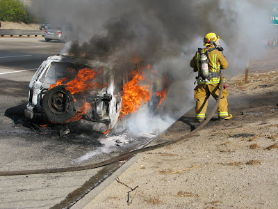
It's already been a trying week for firefighters in several communities. Roadside vehicle fires were a problem on a number of freeways Friday. The one pictured happened about 2:35 p.m. on the eastbound 210 Freeway just west of Muscupiabe Drive.


Temperatures on slopes that burned Thursday above Upland rose to 94 with 6 percent relative humidity on Friday, according to U.S. Forest Service and CalFire personnel below Cucamonga Peak.


Later Friday a brush fire in Beaumont burned more than 35 acres, according to CalFire-Riverside County spokeswoman Cheri Patterson. The fire was contained at 5 p.m. Crews were expected to remain on fire lines through the night.

The cause of the fire was determined to be equipment use during a vehicle salvage, according to Patterson. Fire investigators would like to speak with someone who was driving a late model blue Chevy or GMC pickup truck in the area. Patterson encouraged anyone with information to call 1-800-633-2836.


CalFire-San Bernardino County Firefighter Phillip Marquez from Devore Engine 3577 packs out 50 pounds of hose Friday. Firefighters and inmates carried 3,000 to 5,000 linear feet of hose off slopes that burned Thursday above Upland.

Photos by Guy McCarthy.

-30-

inland heat


Vehicle explodes about 2:35 p.m. today on the 210 Freeway
in San Bernardino. No one was injured.

By Guy McCarthy

SAN BERNARDINO - From Upland to Beaumont, it's difficult to say who was warmest this afternoon in the Inland Empire.

Firefighters and inmate crews in the burned areas above Upland dealt with 94-degree heat, 6 percent relative humidity, and black widow spiders while they packed out 3,000 to 5,000 linear feet of hose from blackened slopes below Ontario and Cucamonga peaks.

Several hours later, more crews rushed to a brush fire that broke out about 3:20 p.m. at Lambs Canyon Road and Beaumont Avenue, according to CalFire-Riverside County spokeswoman Massiel De Guevara. No structures were immediately threatened.


A number of roadside vehicle fires were reported on freeways across Southern California today, and the 210 in San Bernardino was no exception.

Unfortunate but still lucky to be alive, Manuel Gurrola, 77, of San Bernardino said he drove over a mattress that got caught under his vehicle and he could not pull over right away.


By the time he stopped on the eastbound shoulder of the 210 at about 2:35 p.m., just west of Muscupiabe Drive, sparks from the bed springs and heat from the undercarriage set the vehicle aflame.

"He got out but he didn't want to move away from the flames at first," said Christina Perez, 20, who pulled over with her father Joaquin to help if they could. "My father got him to back off some, and that's when it exploded. We're glad he's okay."


San Bernardino Medic Engine 223 arrived within minutes, and Firefighter Nick Munoz doused the vehicle and roadside brush ignited by the flames.

The latest report from Beaumont was the brush fire had burned 50 to 100 acres, with no containment estimate shortly before 5 p.m., De Guevara said in a phone interview.


Burned slopes today below Cucamonga Peak.

Slideshows are here and here. Photos by Guy McCarthy.
-30-

Thursday, October 23, 2008

cucamonga canyon


Looking west over Cucamonga Canyon, July 2005.

By Guy McCarthy

UPLAND - About 400 firefighters were assigned to a 200-acre blaze burning this afternoon on slopes scorched five years ago in the Grand Prix Fire, according to Cal Fire and San Bernardino County fire officials.

The fire was reported at 2:04 p.m. near the north end of Euclid Avenue in Upland, said Cal Fire spokeswoman Suzanne Penfold. Firefighters stopped the flames from reaching any homes and the fire moved north into the wash at the mouth of Cucamonga Canyon, Penfold said.

No structures were immediately threatened and no evacuations had been ordered.

As of 5:30 p.m., officials estimated the fire was 30 percent contained and burning in the San Bernardino National Forest, said Cal Fire spokesman Jesse Estrada. One firefighter had been hospitalized due to an unspecified allergic reaction, Estrada said.

The Grand Prix Fire burned more than 69,000 acres and destroyed 194 homes in October 2003, according to U.S. Forest Service fire and aviation records.

The vegetation that has grown back in the past five years is not nearly as dense as unburned chaparral typically found at elevations near the mouth of Cucamonga Canyon.

San Bernardino County Fire spokeswoman Megan Blaney described the fuels burning today near San Antonio Heights as "light and flashy."

-30-

shades of red


Skycrane west of Porter Ranch last week.

By Guy McCarthy

SAN BERNARDINO - The National Weather Service has extended red flag warnings through Saturday night across much of Southern California due to expected low humidity and critical fire weather conditions.

Santa Ana winds have slacked off considerably, but the continued spell of dry heat should remain a concern to fire crews and residents, according to Weather Service updates this afternoon.

Areas noted by the Weather Service include the San Gabriel Valley, the Santa Monica Mountains, the Santa Clarita Valley, and the Angeles, Cleveland and San Bernardino national forests.

Red flag warnings from the Weather Service today mean "that critical fire weather conditions are occurring. A combination of low relative humidity . . . very warm temperatures . . . and critical fuels will create explosive fire growth potential."

The Weather Service warnings are not to be confused with a new system of colored flag warnings devised in the foothill city of Sierra Madre, where officials are also concerned about the potential for devastating post-fire debris flows.

In Sierra Madre, a red flag means go - leave immediately - according to a new warning system announced this week. The Sierra Madre system also includes green and yellow flags.

Red flags won't come out until heavy rains are expected on burned watersheds from the Santa Anita Fire in April and May 2008, said city spokeswoman Elisa Weaver.

But Sierra Madre officials aren't taking any chances with the post-fire situation, Weaver said.

"Our biggest challenge at this point is making sure people understand," Weaver said in a phone interview. "The fires were burning right in people's back yards. We're based right up against these hills."

In Southern California, a steady rain on recently burned slopes can unleash tons of ash and destabilized soil. Depending on rain intensity, the size of the watershed and grade of the slopes, a post-fire debris flow can ooze along at 5 mph or reach freeway speeds - and in either case they can be deadly.

Post-fire debris flows killed 16 people in canyons north of San Bernardino on Christmas 2003.

Some Sierra Madre officials remember a post-fire debris flow that killed two in Bailey Canyon, several months after the devastating Kinneloa Fire of October 1993.

"We don't want to scare people," Weaver said. "We just want them to be aware of the possibilities and to be ready to evacuate when necessary."

A public meeting is scheduled to address the new warning system in early November.

More information is available at the city of Sierra Madre's site.

-30-

Wednesday, October 22, 2008

'near miss'


Between Hunter's Ridge and Sheridan Estates.

By Guy McCarthy

FONTANA - Somebody set off fireworks in gusting Santa Ana winds early Wednesday, igniting a 250-acre wildfire that burned from north Fontana into Rancho Cucamonga, forced some foothill homeowners to evacuate, and closed two schools, fire officials said.

Blasting winds also played a role in a second fire that broke out before noon and burned about two acres in a south Fontana industrial area off Mulberry Avenue.

A red flag warning for gusting winds and heightened fire danger remains in effect for the mountains and valleys of southwest California through Friday, according to the National Weather Service.

The point of origin for the first fire was near the high end of Foxborough Drive, above the San Sevaine flood control channel and north of Interstate 15. It was initially reported at 12:43 a.m., said U.S. Forest Service spokesman Chon Bribiescas.

"We woke up at 2:30 and it seemed like it was in our back yard," said Rancho Cucamonga resident Charlotte Martinson, raising her voice to make herself heard above the winds. "It was pitch black and we could see the flames. It was 2003 all over again."

Martinson referred to the Grand Prix Fire of October 2003, which burned more than 69,000 acres and destroyed 194 homes, according to U.S. Forest Service fire and aviation records.

"The firefighters did an unbelievable job to knock it down," Martinson said, struggling to remain upright in the gusting winds. "They really deserve credit."

The Grand Prix Fire was ignited by an ATV rider in the same area, five years ago Tuesday, said San Bernardino County Fire spokeswoman Tracey Martinez.


Inmate crew prepares for windy work in burned areas.

"It's a near miss, because the residents here have been lulled into thinking the brush that's grown back since the Grand Prix is not enough to fuel a wildfire," shouted Dennis Cisneros, of the Rancho Cucamonga Fire Safe Council.

"What they saw early today is how fast and hot a fire can spread," Cisneros said, holding onto his Fire Safe Council hat as another gust set him back on his heels. "It was low to the ground, but it spread to 100 acres right away."

Etiwanda Colony Elementary and Summit Intermediate were the two schools closed as a precaution, Cisneros said.

"The San Bernardino County board of supervisors needs to make sure their fire codes include brush clearance requirements in utility corridors," Cisneros said. "See where these high tension power lines run on the front of these hillsides?

"This is what they call the wildland urban interface," Cisneros said. "This is exactly the path of the Grand Prix Fire. The vegetation is growing back and clearly these areas can be ignited year-round - not just in these seasonal Santana winds."

San Bernardino County Fire Capt. Dan Trapp said he and his engine crew arrived about 1 a.m. and tried to keep the fire from burning into a steep draw. The winds were too strong.

"We couldn't keep it from crossing the ravine, but we were lucky it didn't climb further up the mountain and come back down on us," Trapp said.

"The lesson is you have to always be prepared in Southern California," Trapp said. "Brush clearance and evacuation plans. Even though this area has a history, people get complacent."

No one had been taken into custody or charged in the Foxborough Fire, Martinez said. Both fires remained under investigation.


Burned slopes Wednesday above Fontana and Rancho Cucamonga.

-30-

Tuesday, October 21, 2008

red flag


Skycrane passes over a burned structure next to
the Ronald Reagan (118) Freeway, Oct. 13 2008.

By Guy McCarthy

SAN BERNARDINO - The National Weather Service has issued a red flag warning for critical fire weather conditions and explosive fire growth potential tonight through Friday in the mountains and valleys of southwest California.

Officials with the San Bernardino National Forest have characterized the forecast Santa Ana wind event as "weak to moderate."

Nonetheless, authorities have beefed up fire response readiness with additional firefighters, aircraft, and extended patrols, according to forest spokesman John Miller.

There are a total of 30 engines assigned to the San Bernardino National Forest this week, as well as four hotshot crews, three tanker planes, three Skycrane helitankers, two other helicopters, and an air attack lead plane ready to respond to fires as they are reported, according to Miller.

"We take the forecasted weather very seriously and add additional resources as needed," Forest Fire and Aviation Chief Michael Dietrich said in a prepared statement. "Even with more patrols we need the public to join in fire prevention, both being careful and reporting suspicious activities immediately."

Last week's winds stoked fires in the San Fernando Valley and in the city of San Bernardino. The Sesnon and Marek fires burned more than 19,000 acres, destroyed more than 50 homes and contributed to two deaths. Fires in San Bernardino gutted several businesses, forced closures of Interstate 215, and threatened neighborhoods at the base of Little Mountain.


Near Porter Ranch, Oct. 13 2008.

Timed to coincide with the heightened state of awareness, the San Bernardino County Mountain Area Safety Taskforce has scheduled a press conference at 11 a.m. Wednesday in upper Waterman Canyon at Highway 18. Officials intend to address fire preparedness, fire history, new building codes, evacuation procedures, fire resource availability and arson awareness.

Those expected to speak include San Bernardino County Fire Chief Pat Dennen, sheriff's Lt. Rick Ells, and Forest Supervisor Jeanne Wade Evans, said sheriff's spokeswoman Jodi Miller.

The press conference will be staged at the site of a commercial structure that was destroyed during the 2003 Old Fire. Sheriff's officials noted this week marks the anniversaries of the Old and Grand Prix fires in 2003, and of the Slide and Grass Valley fires in 2007.

The fires are among the most devastating in county history, leaving more than 1,400 homes in ashes.

Sunday is the anniversary of the 2006 Esperanza Fire, when five U.S. Forest Service firefighters died trying to protect a vacant home near Twin Pines, in the San Jacinto Mountains section of the San Bernardino National Forest.


Early Oct. 23 2007 in Running Springs.
Photos by Guy McCarthy.

-30-

Monday, October 13, 2008

winds dictate


Dusk falls near Mayan Drive

By Guy McCarthy

PORTER RANCH - From San Bernardino to the San Fernando Valley, gusting winds held the upper hand Monday, severely limiting what firefighters and pilots could do as out-of-control fires burned an estimated 10,000 acres, destroyed more than a dozen homes, and contributed to at least one death.

"It was hell, hell in the mountains," said Abdessamad Elyamani, a doctor who feared for the lives of his wife and children as Santa Ana winds hurled a storm of flames and embers into their hillside community.

"I saw it coming so fast," said Elyamani, who lives near the high end of Topanga Canyon Boulevard. "Two or three minutes, that is all. It was huge fumes of smoke and flames, and we could not breathe. It was jumping all over. Embers were flying and starting fires everywhere."

Los Angeles County fire Capt. Tim Bauer and a strike team of five engine crews from East Los Angeles arrived about 11 a.m. and did what they could.

"Winds were reported 75 mph here. It was a firestorm," Bauer said. "Embers were flying sideways into the houses. As soon as we got here, the fire was right upon us."

Bauer and his crews took a chance trying to defend a ridgetop neighborhood with narrow, winding roads and limited water. Several homes burned, but they managed to save more than the flames destroyed.

"We took risks taking the high ground, yes," Bauer said. "But it's risk versus gain. We were sheltered somewhat behind the houses. . . . No, it's not a safe place for a firefight. Narrow streets, hilltop, and only a few hydrants."

Elyamani's home did not burn, but several of his neighbors' homes further uphill on Mayan Drive were gutted.

"We will try to spend the night," Elyamani said, walking down from Mayan as a smoky, orange dusk turned slowly to darkness. "But you see these embers on the hill? If they cross the street we are gone."

He pointed at the slope across the road from his home as wind fanned tiny, glowing hot spots into flames. He turned towards his home with his wife and boys, ages 4 and 8.

"We hope we are going to be okay."

Earlier Monday, about 80 miles east at the Forest Service Tanker Base in San Bernardino, aviation officer Tom Inocencio said blasting winds and turbulence in the morning prevented he and his pilot from making it to the fires burning in the San Fernando Valley.

"They sent us to the fire at Little Tujunga, the one they call Marek," Inocencio said. "We made it to west of Cucamonga Peak, above Rancho and Ontario, but we had updrafts and downdrafts coming off the mountains.

"We were losing and gaining 2,000 feet elevation per minute," Inocencio said. "It was like being weightless for a second, then getting jammed down in your seat. Wilder than a rollercoaster."

Inocencio and private contract pilot Ryan Litten were in a twin-engine Aero Commander, a lead plane for tankers that drop retardant and water. The blasting winds kept many aircraft grounded at the same time the fires blew up, according to accounts at the tanker base and in the Porter Ranch area.

"It's a decision we have to make sometimes," Litten said. "Every aircraft has limitations and if conditions exceed those limitations we have to set it down. It wasn't fun this morning. Everything in the cabin was flying around."

Inocencio said he learned the winds had grounded all fixed-wing tankers flying out of Lancaster. Watching television coverage of the fires in the San Bernardino tanker base kitchen, Inocencio drew a few conclusions.

"These aren't the kinds of fires where aircraft are effective," Inocencio said. "The winds just take the water or retardant and spread it out. Drops just drift away, off target. When it blows this hard, the real work gets done on the ground."

It was about 1:30 p.m. By that time, Inocencio said he'd had to turn down two additional dispatches because of the winds.

"We're getting 30 knot cross-winds here right across the deck," Inocencio said. "We had sustained readings at Santiago Peak in Orange County of 70 mph. Top speed gust reading was 117 mph at Santiago."

Some helicopter pilots in Los Angeles County managed to fly, and by late afternoon tanker planes made at least a few drops on the fires in the San Fernando Valley. Earlier in the day, Inocencio said some of the aerial attacks were just for show.

"It looks good because people want to see their tax dollars at work," Inocencio said. "But it's risk versus gain. Is it worth the risk to put on a show like that, when it doesn't do much on the fire?

"It's been a rough day so far. Maybe tomorrow will be better. But the latest models show the winds will keep going into Wednesday."

-30-


Photos by Guy McCarthy

Thursday, October 9, 2008

extra crews


Skycrane detail, November 2007.
Photo by Guy McCarthy.

Thursday, Oct. 9 2008 - More fire crews are shifting to Southern California today as Santa Ana winds are expected to return this weekend. Additional aircraft are already on standby.

The Forest Service issued this press release today:

###

VALLEJO, Calif. – In preparation for forecasted Santa Ana winds this weekend the Forest Service is bolstering its fire response readiness with additional firefighters, aircraft, and extended patrols.

This Sunday and Monday, weather forecasts are calling for the first Santa Ana wind event of the year. In response, local forests are staffing firefighters for 24 hour shifts and 20 additional engines, 12 heavy air tankers, and six Sky Crane helitankers have been moved into the area to assist with initial attack. Additionally, the Forest Service has requested the Air National Guard provide two Modular Airborne Fire Fighting System (MAFFS) equipped C-130 aircraft to assist with potential firefighting needs.

“We have already had a long and difficult fire season in Northern California this year,” said Pacific Southwest Regional Forester Randy Moore, “but as the fire season transitions into Southern California we will remain alert and proactively shift firefighters ahead of Santa Ana winds to improve our ability to stop wildfires before they can grow out of control.”

Locally, on the San Bernardino National Forest, an additional five engines will supplement the usual 25 local Forest Service engines, totaling 30 engines on extended staffing, as well as four hotshot crews, three airtankers, two helitankers, two helicopters, an air attack plane, and addition initial attack support. An additional four single engine airtankers can be available within four hours.

“San Bernardino National Forest firefighters continue doing a tremendous job taking immediate and aggressive action suppressing wildland fires on the forest,” said Forest Supervisor Jeanne Wade Evans. “Now as we potentially face our first Santa Ana winds of the season, we’re ramping up our fire fighting resources and law enforcement patrols.”

Each fall in Southern California, Santa Ana winds have the potential to rapidly spread wildfires which makes rapid response to fires extremely important. Although the Forest Service and partnering firefighting agencies in Southern California are doing their part to prepare for potential wildfires this fall, it is equally important for local citizens to do their part.

Citizens can help firefighters by ensuring that their homes have defensible space and by being especially careful with open flames, sparks, and other heat sources.

Additionally, citizens living near the wildland-urban interface should keep an eye out for arson and report arson activity immediately by dialing 911.

###


On standby, November 2007. Photo by Guy McCarthy.

Meanwhile, a study released today shows wildfires cause ozone pollution levels that can exceed health standards.

The study, conducted by scientists at the National Center for Atmospheric Research, focused on California wildfires in October and September 2007.

NCAR scientists Gabriele Pfister and Christine Wiedinmyer found the fires repeatedly caused ground-level ozone to spike to unhealthy levels across a broad area, including much of rural California as well as neighboring Nevada.

The study is copyrighted by the American Geophysical Union.

-30-

Tuesday, September 30, 2008

teamwork


Photo courtesy of Capt. Tim Bingham, CalFire-Riverside County.

IDYLLWILD - It was one month ago today - on Saturday Aug. 30 - when two Orange County climbers were severely injured after a 100-foot leader fall at Suicide Rock.

Both are expected to fully recover, thanks to the teamwork of other climbers already at Suicide and firefighter-paramedics from Idyllwild and Pine Cove.

In the photo above, a climber works with firefighters to stabilize one of the injured on a trail at the base of Suicide Rock.

Reports on the accident and rescues are here and here.

-30-

Friday, September 26, 2008

canyon perspective


Mill Creek Canyon and Forest Falls from Galena Peak, Aug. 26 2008.

By Guy McCarthy

FOREST FALLS - If anyone in this mountain town had heard of a federal study showing many residents in the San Bernardino National Forest experience stress from living in such a fire-prone region, they weren't letting on to it Friday.

At Forest Falls Fire Station 128, two county firefighters politely referred questions to Capt. Tom McIntosh.

In his office at Gillmore Real Estate, McIntosh said he hadn't heard of the study, and he was too busy with other work to consider it at the moment.

Across the street at the Elkhorn General Store, co-owner Gail Forgues said she hadn't heard of the study either. During busy weekends and the occasional town emergency, her store often serves as information central.

Forgues expressed confidence in federal management of the San Bernardino National Forest, but admitted she was not sure what to expect from the next presidential administration as far as forest maintenance.

She said she wasn't expecting many people to watch the Obama-McCain debate tonight on the store's flat-screen television.

"I'm not sure what I'd ask them about," Forgues said, given an opportunity to form a question for the two candidates. "I'd have to think about it."

The semi-rustic Elkhorn General Store stands at roughly 6,000 feet elevation, next to the popular El Mexicano eatery in the center of Forest Falls. The town is about 80 miles east of Los Angeles in Mill Creek Canyon, which lies below the San Gorgonio Wilderness.


Bulletin board at Elkhorn General Store.

In recent years, federal grants helped pay for expensive helicopter removal of hundreds of dead trees on slopes above Forest Falls. Helicopter logging is dangerous and can cost up to $100 per tree.

McIntosh and others in the community are experienced in firefighting, alpine rescue, swift-water rescue, house-to-house search-and-rescue, and debris removal. Long-time Forest Falls residents reflect their rugged surroundings, and many are self-reliant and competent in emergencies.

In the past century, Forest Falls residents have experienced earthquakes, floods, rock avalanches and debris flows - but no serious fires. Other parts of the forest have burned repeatedly in the past 100 years. But not upper Mill Creek Canyon.

New residents are aware of the history, though they don't dwell on it.

"We know about what they say," said Roger Derda, a former community development and planning director in Banning who moved to Forest Falls recently. He was painting the side of his home Friday afternoon, further up-stream from the Elkhorn, El Mexicano and Gillmore.

"They say it's a box canyon and all that," Derda said. "We're not concerned."


Yucaipa Ridge and Mill Creek Canyon from Galena Peak, Aug 26 2008.

The San Bernardino National Forest covers more than 1,000 square miles in San Bernardino and Riverside counties.

-30-

fire-prone stress


Running Springs, early Oct. 23 2007. Photo by Guy McCarthy.

RIVERSIDE - A federal study released Wednesday evening shows that many residents in fire-prone communities surrounded by the San Bernardino National Forest - one of the most flammable in the United States - have stress and anxiety related to living in high-hazard areas.

Focus groups for the study were held in Angelus Oaks, Forest Falls, Lake Arrowhead, Crestline, Big Bear, Wrightwood and Idyllwild in March and April 2007 - before the destructive fires of October 2007.

Psychological impacts can linger for years after a fire, according to "The Experience of Community Residents in a Fire-Prone Ecosystem: A Case Study on the San Bernardino National Forest."

The study was completed this summer by Patricia Winter, a U.S. Forest Service research social scientist at the Forest Fire Laboratory in Riverside, and George Cvetkovich, a psychology professor at the Western Washington University Center for Cross-Cultural Research.

Winter and Cvetkovich conducted the study in the San Bernardino National Forest because it is one of the most fire-prone in the country, according to the Forest Service.

It is also the nation's most urbanized mountain forest, with more than 100,000 residents from Wrightwood to Idyllwild.

Recent destructive fires in the San Bernardino National Forest include the Old Fire of October 2003, the Esperanza Fire of October 2006, and the Slide and Grass Valley fires of October 2007. Hundreds of homes have been lost in the past five years, and the death toll includes the five-man crew of U.S. Forest Service Engine 57, who died Oct. 26 2006 as they tried to protect a vacant home in the San Jacinto Mountains.

Howling Santa Ana winds - an annual feature of Southern California weather - helped create firestorm conditions at times during each of these incidents.

"The communities included in this study are adjacent to the national forest and other federal lands and have been listed by the California Department of Forestry and Fire Protection as Hazard Level Code 3, indicating the highest fire threat level," Winter and Cvetkovich wrote in their introduction.

Most residents in fire-prone communities surrounded by the San Bernardino National Forest have taken steps to protect their homes from wildland fires, according to Winter and Cvetkovich.

About 94 percent of homeowners who participated in surveys and focus group discussions in 2007 had taken defensible-space steps, according to the study. About 75 percent reduced flammable vegetation because it was required.

But inadequate financial resources, physical limitations, and a desire to leave the landscape unchanged were commonly cited as reasons for not taking action to protect homes from wildland fires, according to Winter and Cvetkovich.

The study can be found at this address:
http://www.fs.fed.us/psw/publications/documents/psw_rp257/


Early Oct. 23 2007 in Running Springs. Photo by Guy McCarthy.

For a report from Running Springs during the Slide Fire, click here.

-30-